
Eight days, one transformed landscape
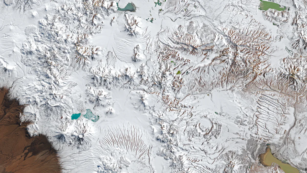
NASA Earth Observatory published two Landsat views of the Chajnantor Plateau in northern Chile. Landsat 8's Operational Land Imager recorded the first on August 6, before the severe weather. Landsat 9 recorded the second on August 14, after snow covered much of the normally exposed high-altitude terrain.
The published comparison uses the same geographic crop, scale and 16:9 format for both dates. It keeps August 6 first and August 14 second without a synthetic divider, overlay or generated terrain; the dates remain in the captions rather than the pixels.
The event extended beyond the plateau
NASA Earth Observatory described parts of the Atacama as receiving a rare blanket of snow and called one of the August events unusually widespread. Those labels apply to the regional episode; the August 14 Chajnantor image alone does not establish the Andes-to-coast extent, and snowfall at this altitude is not unprecedented.
A Terra MODIS observation from August 19 showed snow extending west from the Andes, across the Atacama's hyper-arid core and close to the Pacific coast south of Antofagasta. Separately, ALMA's official account reported on August 17 that operations remained suspended and its antennas were in survival mode after new snow and high winds. That is a dated operational update, not a claim about current status or damage.
What the images establish
The comparison establishes surface conditions at two documented times. Matching geographic crops make the visible change at one location easier to compare, while the source chain identifies the satellites, instruments, dates and image producer.
It is not a continuous time series or a snow-depth product. The pair does not show exactly when the snow fell, how long it remained or how the storm evolved between acquisitions. White areas are described according to NASA's caption rather than classified independently from appearance.
Weather context without a climate shortcut
NASA Earth Observatory describes the later, broader August event as a cutoff low associated with an unusually large atmospheric trough. Coastal moisture helped precipitation spread across a wide area, while a strengthening El Niño formed part of the large-scale background to the wet winter.
Background is not single-cause attribution. These snapshots cannot establish a long-term climate trend or attribute this event to climate change. Such a conclusion would require longer records, specialist analysis and evidence designed for attribution rather than a visually striking comparison.
Sources & Methods
LUMACTA NEWS uses the official August 14 Landsat observation as the hero and compares it with the August 6 observation using the same geographic crop and scale. Both NASA source masters were re-downloaded on August 30 and matched the retained checksums. No terrain, snow, label or date is generated into the files.
- NASA Earth Observatory — Rare, Widespread Snow in the Atacama Desert — primary source
- ALMA Observatory — August 17 operational update — primary source
- NOAA Climate Prediction Center — ENSO Diagnostic Discussion, August 13, 2026 — primary context
- USGS — Landsat data and the public domain — rights source
- USGS — Restrictions on Landsat data use or redistribution — rights source
- NASA — Images and Media Usage Guidelines — rights source